Djibouti Map - Djibouti

Djibouti (/dʒɪˈbuːti/ ji-boo-tee; Arabic: جيبوتي
Jībūtī, French: Djibouti, Somali: Jabuuti, Afar: Gabuuti), officially the
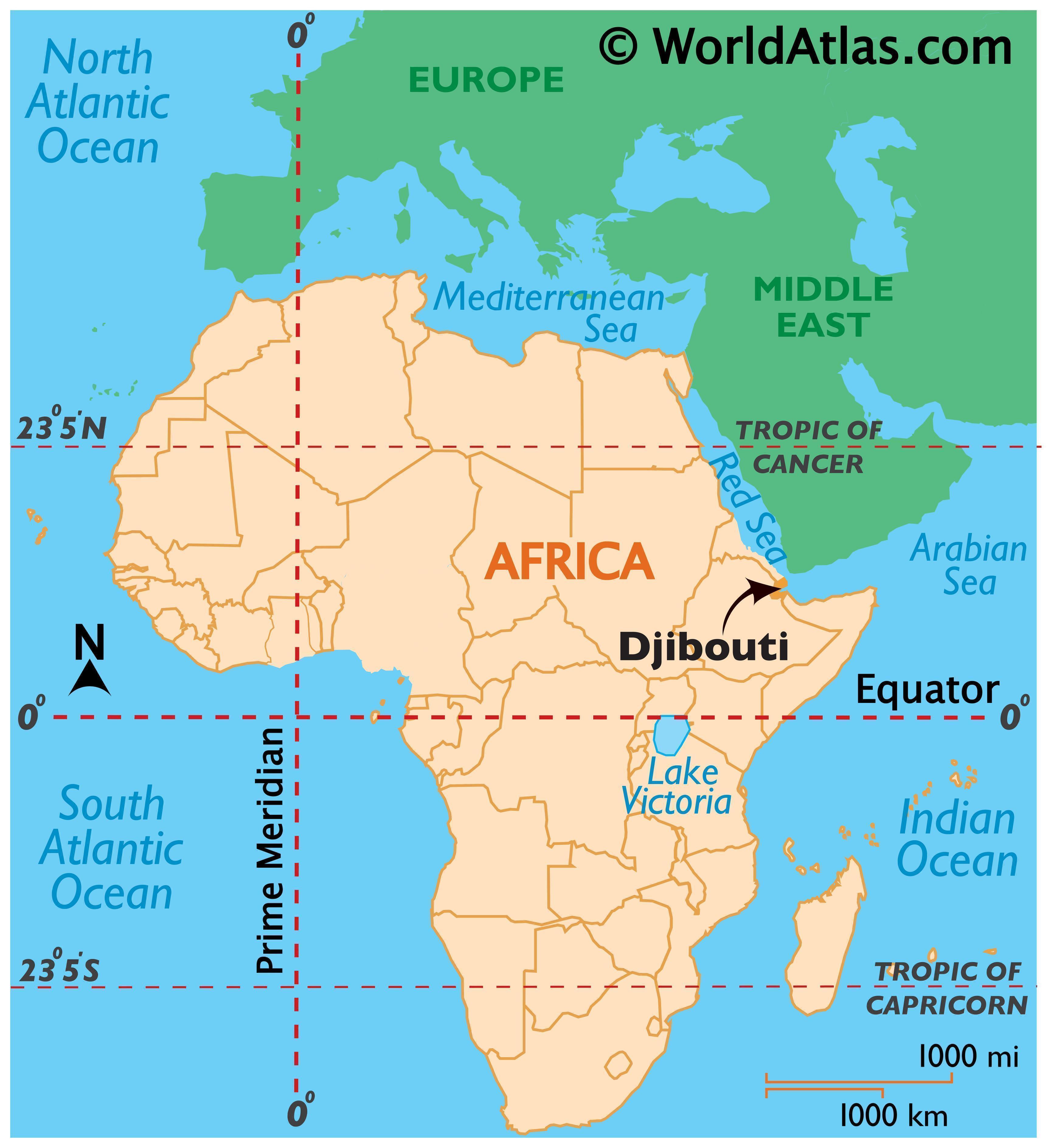
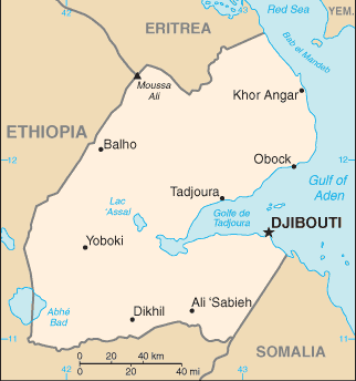
Republic of Djibouti, is a country located in the Horn of Africa. It is
bordered by Eritrea in the north, Ethiopia in the west and south, and Somalia
in the southeast. The remainder of the border is formed by the Red Sea and the
Gulf of Aden at the east. Djibouti occupies a total area of just 23,200 km2
(8,958 sq mi).
Djibouti Map / Geography of Djibouti
In antiquity, the territory was part of the Land of Punt. Nearby Zeila (now in Somalia) was the seat of the medieval Adal and Ifat Sultanates. In the late 19th century, the colony of French Somaliland was established following treaties signed by the ruling Somali and Afar sultans with the French[5][6][7] and its railroad to Dire Dawa (and later Addis Ababa) allowed it to quickly supersede Zeila as the port for southern Ethiopia and the Ogaden.[8] It was subsequently renamed to the French Territory of the Afars and the Issas in 1967. A decade later, the Djiboutian people voted for independence. This officially marked the establishment of the Republic of Djibouti, named after its capital city. Djibouti joined the United Nations the same year, on September 20, 1977.[9][10] In the early 1990s, tensions over government representation led to armed conflict, which ended in a power sharing agreement in 2000 between the ruling party and the opposition.[1]
Djibouti is a multi-ethnic nation with a population of over 810,000 inhabitants. Arabic and French constitute the country's two official languages. About 94% of residents adhere to Islam,[1] a religion that has been predominant in the region for more than 1,000 years. The Somali Issa and Afar make up the two largest ethnic groups. Both speak Afroasiatic languages, which serve as recognized national languages.
Djibouti Maps - Perry
Djibouti is strategically located near the world's busiest shipping lanes, controlling access to the Red Sea and Indian Ocean. It serves as a key refueling and transshipment center, and is the principal maritime port for imports to and exports from neighboring Ethiopia. A burgeoning commercial hub, the nation is the site of various foreign military bases, including Camp Lemonnier. The Intergovernmental Authority on Development (IGAD) regional body also has its headquarters in Djibouti City.[1]
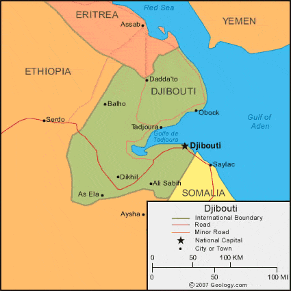
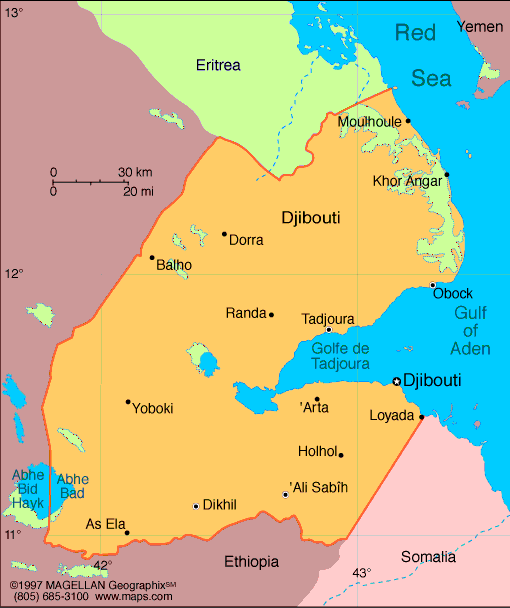
Map of Djibouti
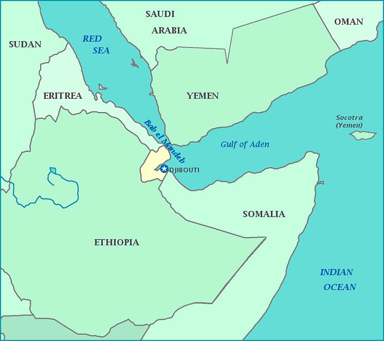
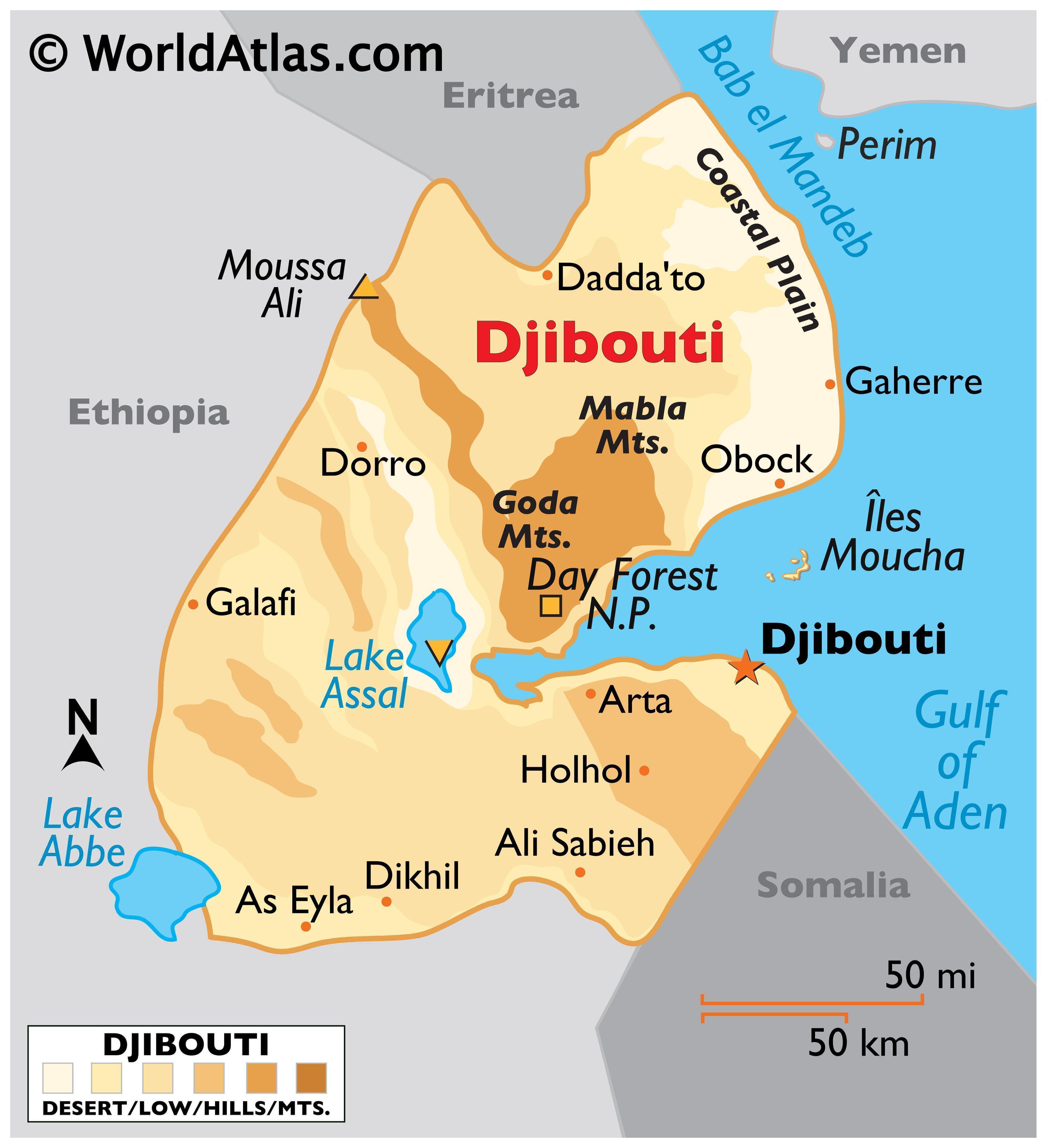
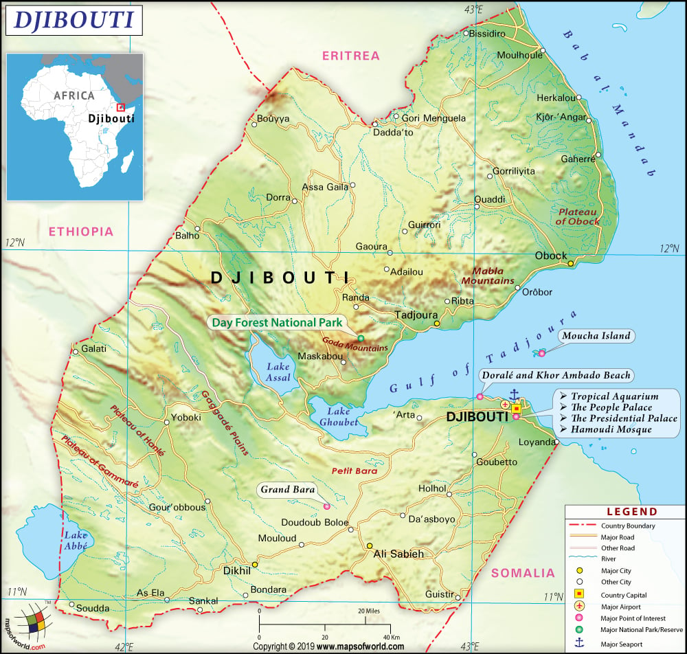
Djibouti is situated in the Horn of Africa on
the Gulf of Aden and the Bab-el-Mandeb, at the southern entrance to the Red
Sea. It lies between latitudes 10° and 13°N, and longitudes 41° and 44°E,
within the Arabian Plate. The country's coastline stretches 314 kilometres (195
miles), with terrain consisting mainly of plateaux, plains and highlands.
Djibouti has a total area of 23,200 square kilometres (9,000 sq mi).[1] Its
borders extend 506 km (314 mi), 113 km (70 mi) of which are shared with
Eritrea, 337 km (209 mi) with Ethiopia, and 58 km (36 mi) with Somalia.
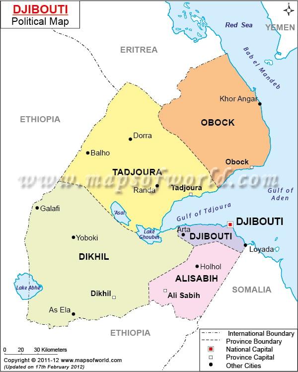
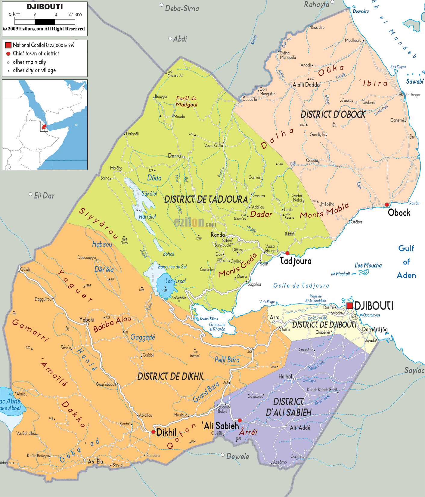
Political Map of Djibouti
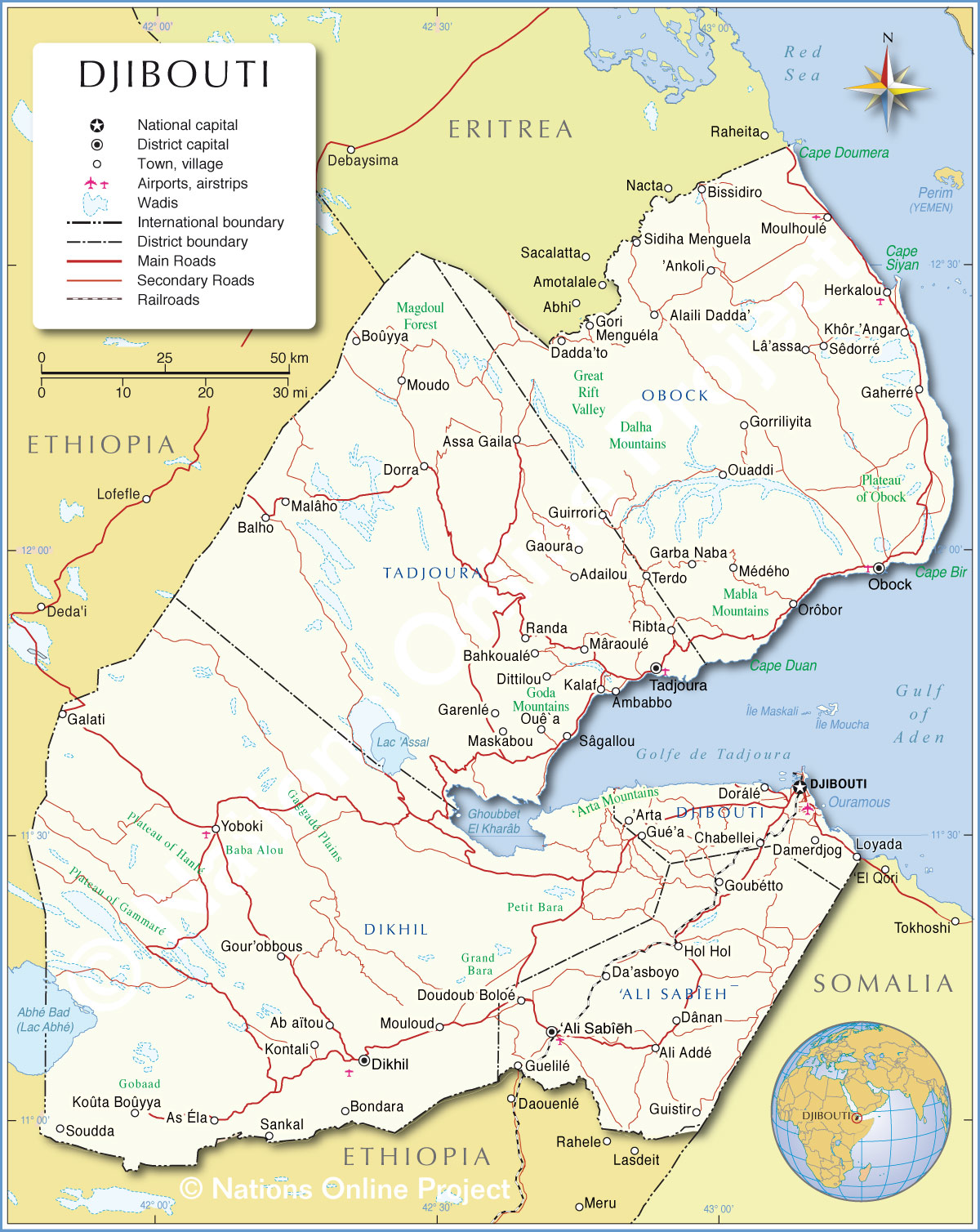
Djibouti has eight mountain ranges with peaks of over 1,000 m (3,281 ft).[44] The Mousa Ali range is considered the country's highest mountain range, with the tallest peak on the border with Ethiopia and Eritrea. It has an elevation of 2,028 m.[44] The Grand Bara desert covers parts of southern Djibouti in the Arta, Ali Sabieh and Dikhil regions. The majority of it sits at a relatively low elevation, below 1,700 feet (560 m).
Extreme geographic points include: to the north, Ras Doumera and the point at which the border with Eritrea enters the Red Sea in the Obock Region; to the east, a section of the Red Sea coast north of Ras Bir; to the south, a location on the border with Ethiopia west of the town of As Ela; and to the west, a location on the frontier with Ethiopia immediately east of the Ethiopian town of Afambo.
Most of Djibouti is part of the Ethiopian xeric grasslands and shrublands ecoregion. The exception is a strip along the Red Sea coast, which is part of the Eritrean coastal desert.[45]
Djibouti Map / Geography of Djibouti / Map of Djibouti ...
Djibouti's climate is significantly warmer and
has significantly less seasonal variation than the world average. Mean daily
maximum temperatures range from 32 to 41 °C (90 to 106 °F), except at high
elevations, where the effects of a cold offshore current can be felt. In
Djibouti city, for instance, average afternoon highs range from 28 to 34 °C (82
to 93 °F) in April. Nationally, mean daily minimums usually vary from 15 to 30
°C (59 to 86 °F).[46] The greatest range in climate occurs in eastern Djibouti,
where temperatures sometimes surpass 41 °C (106 °F) in July on the littoral
plains and the freezing point during December in the highlands.[46] In this
region, relative humidity ranges from about 40% in the mid-afternoon to 85% at
night, changing somewhat according to the season.
Djibouti's climate ranges from arid in the
northeastern coastal regions to semiarid in the central, northern, western and
southern parts of the country. On the eastern seaboard, annual rainfall is less
than 5 inches (131 mm); in the central highlands, precipitation is about 8 to
11 inches (200 to 300 mm). The hinterland is significantly less humid than the
coastal regions. The coast has the mildest climates in Djibouti.
Djibouti Map - Djibouti Satellite Image - Physical - Political
The country's flora and fauna live in a harsh
landscape with forest accounting for less than one percent of the total area of
the country.[47] Wildlife is spread over three main regions namely, from the
northern mountain region of the country to the volcanic plateaux in its
southern and central part and culminating in the coastal region.
Most species of wildlife are found in the
northern part of the country, in the ecosystem of the Day Forest National Park.
At an average altitude of 1,500 metres (4,921 feet), the area includes the Goda
massif, with a peak of 1,783 m (5,850 ft). It covers an area of 3.5 square
kilometres (1 sq mi) of Juniperus procera forest, with many of the trees rising
to 20 metres (66 feet) height. This forest area is the main habitat of the
endangered and endemic Djibouti francolin (a bird), and another recently noted
vertebrate, Platyceps afarensis (fr) (a colubrine snake). It also contains many
species of woody and herbaceous plants, including boxwood and olive trees,
which account for 60% of the total identified species in the country.
Political Map of Djibouti
According to the country profile related to biodiversity of wildlife in Djibouti, the nation contains more than 820 species of plants, 493 species of invertebrates, 455 species of fish, 40 species of reptiles, 3 species of amphibians, 360 species of birds and 66 species of mammals.[47] Wildlife of Djibouti is also listed as part of Horn of Africa biodiversity hotspot and the Red Sea and Gulf of Aden coral reef hotspot.[48]
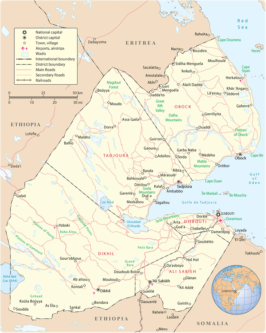
Physical Map of Djibouti
Djibouti's economy is largely concentrated in
the service sector. Commercial activities revolve around the country's free
trade policies and strategic location as a Red Sea transit point. Due to
limited rainfall, vegetables and fruits are the principal production crops, and
other food items require importation. The GDP (purchasing power parity) in 2013
was estimated at $2.505 billion, with a real growth rate of 5% annually. Per
capita income is around $2,874 (PPP). The services sector constituted around
79.7% of the GDP, followed by industry at 17.3%, and agriculture at 3%.[1]
As of 2013, the container terminal at the Port
of Djibouti handles the bulk of the nation's trade. About 70% of the seaport's
activity consists of imports to and exports from neighboring Ethiopia, which
depends on the harbour as its main maritime outlet. The port also serves as an
international refueling center and transshipment hub.[1] In 2012, the
Djiboutian government in collaboration with DP World started construction of
the Doraleh Container Terminal,[49] a third major seaport intended to further
develop the national transit capacity.[1] A $396 million project, it has the
capacity to accommodate 1.5 million twenty foot container units annually.[49]
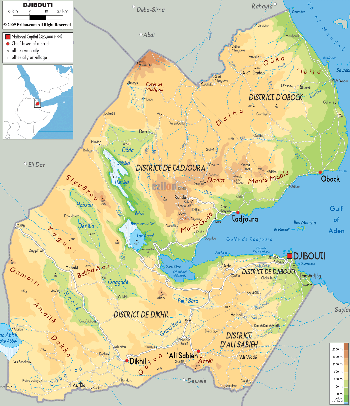
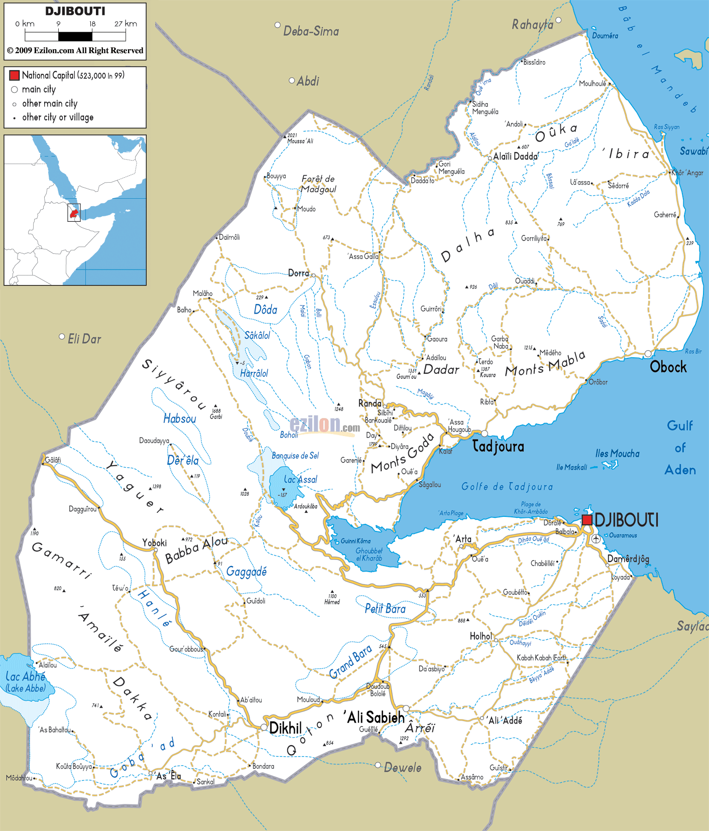
Road Map of Djibouti - Ezilon Maps
Political Map of Djibouti
Djibouti was ranked the 177th safest investment destination in the world in the March 2011 Euromoney Country Risk rankings.[50] To improve the environment for direct foreign investment, the Djibouti authorities in conjunction with various non-profit organizations have launched a number of development projects aimed at highlighting the country's commercial potential. The government has also introduced new private sector policies targeting high interest and inflation rates, including relaxing the tax burden on enterprises and allowing exemptions on consumption tax.[49]
Graphical depiction of Djibouti's product exports in 28 color-coded categories.
Additionally, efforts have been made to lower the estimated 60% urban unemployment rate by creating more job opportunities through investment in diversified sectors. Funds have especially gone toward building telecommunications infrastructure and increasing disposable income by supporting small businesses. Owing to its growth potential, the fishing and agro-processing sector, which represents around 15% of GDP, has also enjoyed rising investment since 2008.[49]
To expand the modest industrial sector, a 56 megawatt geothermal power plant slated to be completed by 2018 is being constructed with the help of OPEC, the World Bank and the Global Environmental Facility. The facility is expected to solve the recurring electricity shortages, decrease the nation's reliance on Ethiopia for energy, reduce costly oil imports for diesel-generated electricity, and thereby buttress the GDP and lower debt.[49]
A truck operator at Al Gamil, the largest construction company in Djibouti
The Djibouti firm Salt Investment (SIS) began a large-scale operation to industrialize the plentiful salt in Djibouti's Lake Assal region. Operating at an annual capacity of 4 million tons, the desalination project has lifted export revenues, created more job opportunities, and provided more fresh water for the area's residents.[1][49] In 2012, the Djibouti government also enlisted the services of the China Harbor Engineering Company Ltd for the construction of an ore terminal. Worth $64 million, the project is scheduled to be completed within two years[when?] and will enable Djibouti to export a further 5,000 tons of salt per year to markets in Southeast Asia.[51]
Djibouti Cities Map, Major Cities in Djibouti

The Djiboutian franc is the currency of Djibouti. It is issued by the Central Bank of Djibouti, the country's monetary authority. Since the Djiboutian franc is pegged to the U.S. dollar, it is generally stable and inflation is not a problem. This has contributed to the growing interest in investment in the country.[49][52][53]
As of 2010, 10 conventional and Islamic banks operate in Djibouti. Most arrived within the past few years, including the Somali money transfer company Dahabshiil and BDCD, a subsidiary of Swiss Financial Investments. The banking system had previously been monopolized by two institutions: the Indo-Suez Bank and the Commercial and Industrial Bank (BCIMR).[52] To assure a robust credit and deposit sector, the government requires commercial banks to maintain 30% of shares in the financial institution;[clarification needed] a minimum of 300 million Djiboutian francs in up-front capital is mandatory for international banks. Lending has likewise been encouraged by the creation of a guarantee fund, which allows banks to issue loans to eligible small- and medium-sized businesses without first requiring a large deposit or other collateral.[49]
Atlas: Djibouti
Saudi investors are also reportedly exploring the possibility of linking the Horn of Africa with the Arabian Peninsula via a 28.5-kilometre-long (17.7 mi)[54] oversea bridge through Djibouti, referred to as the Bridge of the Horns. The investor Tarek bin Laden has been linked to the project. However, it was announced in June 2010 that Phase I of the project had been delayed.[55]
Djibouti | Operation World

Djibouti is a multiethnic country. The two
largest ethnic groups are the Somali (60%) and the Afar (35%). The Somali clan
component is mainly composed of the Issas, a sub-clan of the larger Dir. The
remaining 5% of Djibouti's population primarily consists of Arabs, Ethiopians
and Europeans (French and Italians). Approximately 76% of local residents are
urban dwellers; the remainder are pastoralists.[1]
In addition, Djibouti is a multilingual nation,
with a population of about 774,389 inhabitants.[1] According to Ethnologue, the
majority of the residents speak Somali (297,000 speakers) or Afar (99,200
speakers) as a first language, which are the mother tongues of the Somali and
Afar ethnic groups, respectively. Both languages belong to the larger Afroasiatic
family. There are two official languages in Djibouti: Arabic (Afroasiatic) and
French (Indo-European). Arabic is of social, cultural and religious importance.
In formal settings, it consists of Modern Standard Arabic. Colloquially, about
36,000 local residents speak the Ta'izzi-Adeni Arabic dialect, also known as
Djibouti Arabic. French was inherited from the colonial period and is the
primary language of instruction. About 10,200 Djiboutians speak it as a first
language. Immigrant languages include Omani Arabic (38,900 speakers), Amharic
(1,400 speakers), Greek (1,000 speakers) and Hindi (600 speakers).[56]
Djibouti maps, Maps of Djibouti, Djibouti maps

The life expectancy at birth is about 62 for
both females and males. Fertility is at 2.63 children per woman.[1] In the
country there are about 18 doctors per 100,000 persons.[60]
In June 2011, the United Nations Population
Fund released a report on The State of the World's Midwifery. It contained new
data on the midwifery workforce and policies relating to newborn and maternal
mortality for 58 countries. The 2010 maternal mortality rate per 100,000 births
for Djibouti is 300. This is compared with 461.6 in 2008 and 606.5 in 1990. The
under 5 mortality rate, per 1,000 births is 95 and the neonatal mortality as a
percentage of under 5's mortality is 37. The aim of this report is to highlight
ways in which the Millennium Development Goals can be achieved, particularly
Goal 4 – Reduce child mortality and Goal 5 – improve maternal health. In
Djibouti the number of midwives per 1,000 live births is 6 and the lifetime
risk of death for pregnant women 1 in 93.[61]
Djibouti - 2015, CIA World Factbook

According to a 2005 World Health Organization estimate, about 93.1% of Djibouti's women and girls have undergone female genital mutilation (female circumcision),[62] a pre-marital custom mainly endemic to Northeast Africa and parts of the Near East that has its ultimate origins in Ancient Egypt.[63][64] Although legally proscribed in 1994, the procedure is still widely practiced, as it is deeply ingrained in the local culture.[65] Encouraged and performed by women in the community, circumcision is primarily intended to deter promiscuity and to offer protection from assault.[65][66] About 94% of Djibouti's male population has also reportedly undergone male circumcision.[67]
Djibouti Guide -- National Geographic

Djibouti's population is predominantly Muslim.
Islam is observed by 94% of the nation's population (around 740,000 as of
2012), while the remaining 6% of residents are Christians.[1]
The Constitution of Djibouti names Islam as the
sole state religion, and also provides for the equality of citizens of all
faiths (Article 1) and freedom of religious practice (Article 11).[32] Most
local Muslims adhere to the Sunni denomination, following the Shafi'i school.
The non-denominational Muslims largely belong to Sufi orders of varying
schools.[68] According to the International Religious Freedom Report 2008,
while Muslim Djiboutians have the legal right to convert to or marry someone
from another faith, converts may encounter negative reactions from their family
and clan or from society at large, and they often face pressure to go back to
Islam.[69]
The Diocese of Djibouti serves the small local
Catholic population, which it estimates numbered around 7,000 individuals in
2006.[70]
Map of Djibouti - Travel Africa
Djiboutian attire reflects the region's hot and
arid climate. When not dressed in Western clothing such as jeans and T-shirts,
men typically wear the macawiis, which is a sarong-like garment worn around the
waist. Many nomadic people wear a loosely wrapped white cotton robe called a
tobe that goes down to about the knee, with the end thrown over the shoulder
(much like a Roman toga).
djibouti-map.jpg
Women typically wear the dirac, which is a long, light, diaphanous voile dress made of cotton or polyester that is worn over a full-length half-slip and a bra. Married women tend to sport head-scarves referred to as shash and often cover their upper body with a shawl known as garbasaar. Unmarried or young women, however, do not always cover their heads. Traditional Arabian garb such as the male jellabiya (jellabiyaad in Somali) and the female jilbāb is also commonly worn. For some occasions such as festivals, women may adorn themselves with specialized jewelry and head-dresses similar to those worn by the Berber tribes of the Maghreb.[71]
djibouti-road-map.jpg

A lot of Djibouti's original art is passed on and preserved orally, mainly through song. Many examples of Islamic, Ottoman, and French influences can also be noted in the local buildings, which contain plasterwork, carefully constructed motifs and calligraphy.
Hiç yorum yok:
Yorum Gönder