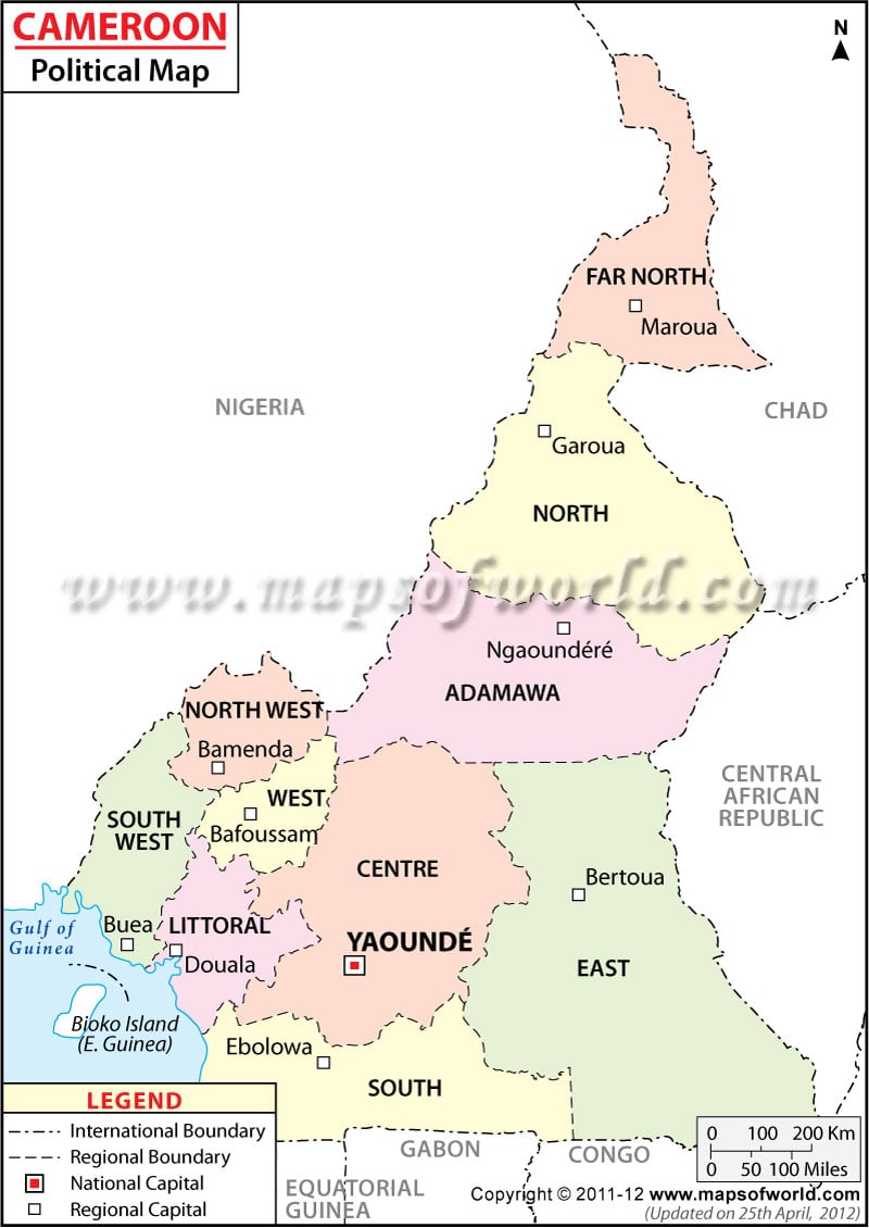
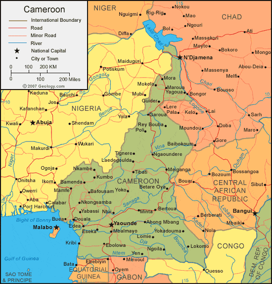
Political Map of Cameroon | Cameroon Regions Map
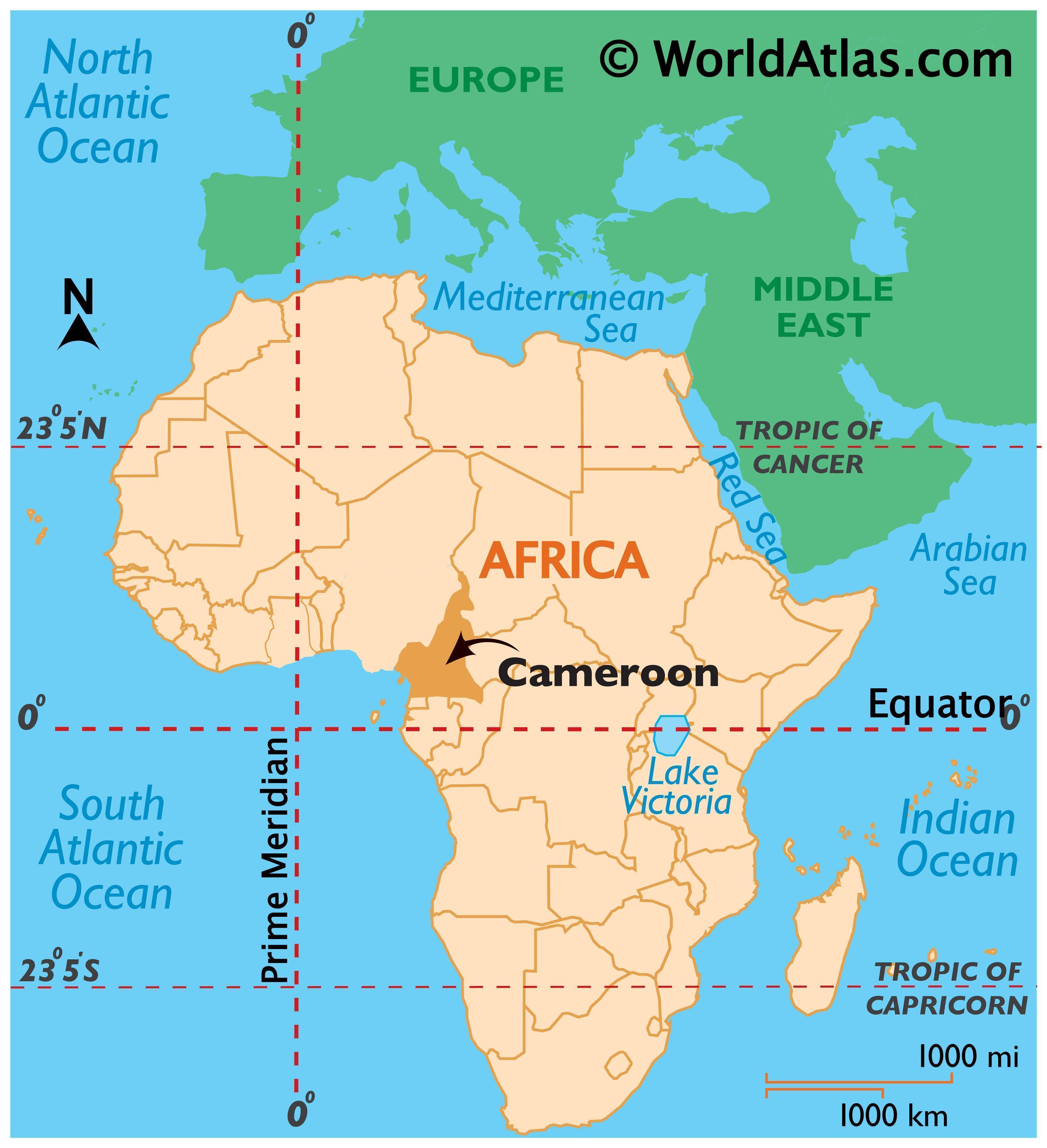
Cameroon (/ˌkæməˈruːn/; French: Cameroun), officially the
Republic of Cameroon (French: République du Cameroun), is a country in Central
Africa. It is bordered by Nigeria to the west; Chad to the northeast; the
Central African Republic to the east; and Equatorial Guinea, Gabon, and the
Republic of the Congo to the south. Cameroon's coastline lies on the Bight of
Bonny, part of the Gulf of Guinea and the Atlantic Ocean.
Cameroon is home to more than 200 different linguistic
groups. French and English are the official languages. The country is often
referred to as "Africa in miniature" for its geological and cultural
diversity. Natural features include beaches, deserts, mountains, rainforests,
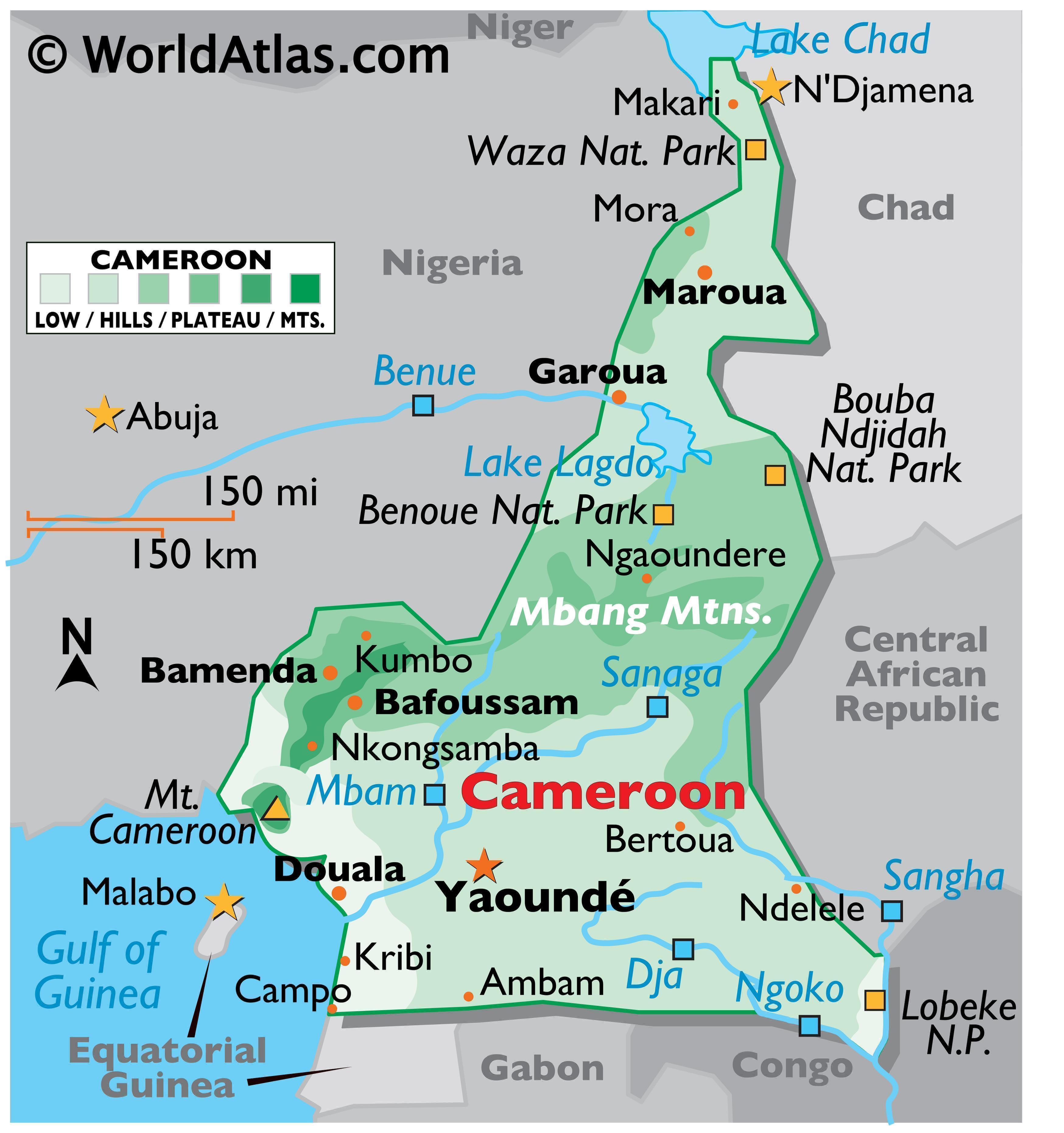
and savannas. The highest point at almost 4,100 metres (13,500 ft) is Mount
Cameroon in the Southwest Region of the country, and the largest cities in
population-terms are Douala on the Wouri river, its economical capital and main
seaport, Yaoundé, its political capital, and Garoua. After independence, the
newly united nation joined the Commonwealth of Nations, although the vast
majority of its territories had previously been a German colony and, after
World War I, a French mandate. The country is well known for its native styles
of music, particularly makossa and bikutsi, and for its successful national
football team.
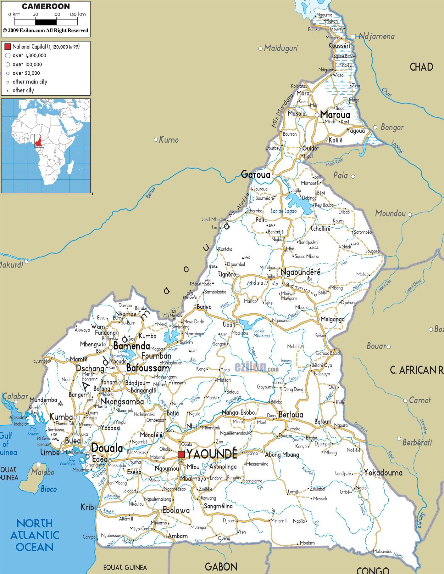
Road Map of Cameroon
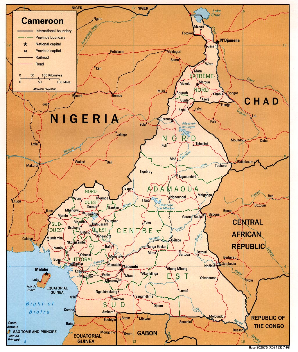
Early inhabitants of the territory included the Sao civilisation around Lake Chad and the Baka hunter-gatherers in the southeastern rainforest. Portuguese explorers reached the coast in the 15th century and named the area Rio dos Camarões (Shrimp River), which became Cameroon in English. Fulani soldiers founded the Adamawa Emirate in the north in the 19th century, and various ethnic groups of the west and northwest established powerful chiefdoms and fondoms. Cameroon became a German colony in 1884 known as Kamerun.
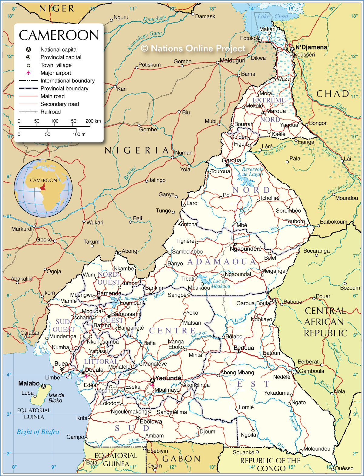
Administrative Map of Cameroon
After World War I, the territory was divided between France and the United Kingdom as League of Nations mandates. The Union des Populations du Cameroun (UPC) political party advocated independence, but was outlawed by France in the 1950s. It waged war on French and UPC militant forces until 1971. In 1960, the French-administered part of Cameroon became independent as the Republic of Cameroun under President Ahmadou Ahidjo. The southern part of British Cameroons merged with it in 1961 to form the Federal Republic of Cameroon. The country was renamed the United Republic of Cameroon in 1972 and the Republic of Cameroon in 1984.
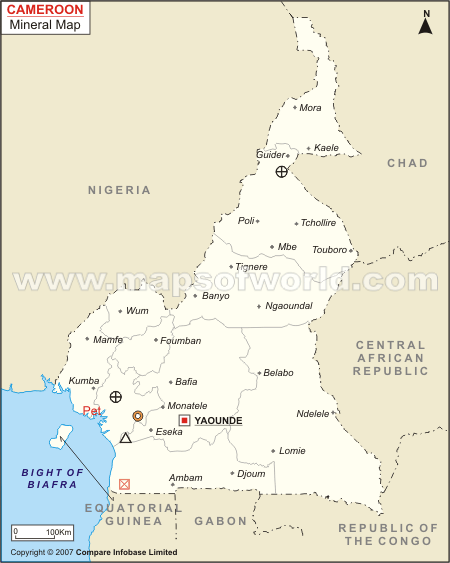
Cameroon Mineral Map | Natural Resources of Cameroon
Cameroon enjoys relatively high political and social stability. This has permitted the development of agriculture, roads, railways, and large petroleum and timber industries. Nevertheless, large numbers of Cameroonians live in poverty as subsistence farmers. Power lies firmly in the hands of the authoritarian president since 1982, Paul Biya, and his Cameroon People's Democratic Movement party. The English-speaking territories of Cameroon have grown increasingly alienated from the government, and politicians from those regions have called for greater decentralization and even secession (for example: the Southern Cameroons National Council) of the former British-governed territories.
Cameroon Malaria Map - Fit For Travel

The President of Cameroon is elected and creates policy,
administers government agencies, commands the armed forces, negotiates and
ratifies treaties, and declares a state of emergency.[26] The president
appoints government officials at all levels, from the prime minister
(considered the official head of government), to the provincial governors and
divisional officers.[27] The president is selected by popular vote every seven
years.[1]
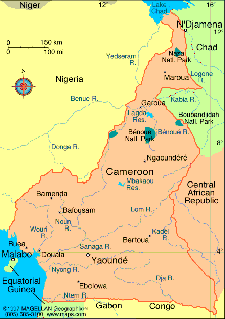
Cameroon Map - Cameroon Satellite Image - Physical - Political
,
The National Assembly makes legislation. The body consists of 180 members who are elected for five-year terms and meet three times per year.[27] Laws are passed on a majority vote. Rarely has the assembly changed or blocked legislation proposed by the president.[1]
The 1996 constitution establishes a second house of parliament, the 100-seat Senate, was established in April 2013 and is headed by a senate president who is the constitutional successor in case of untimely vacancy of the presidency.[1] The government recognises the authority of traditional chiefs, fons, and lamibe to govern at the local level and to resolve disputes as long as such rulings do not conflict with national law.[28][29]
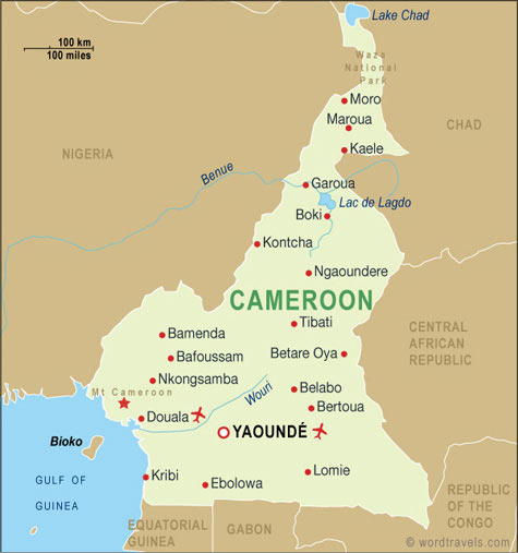
Airports in Cameroon, Cameroon Airports Map

Cameroon's legal system is largely based on French civil law with common law influences.[1] Although nominally independent, the judiciary falls under the authority of the executive's Ministry of Justice.[28] The president appoints judges at all levels.[27] The judiciary is officially divided into tribunals, the court of appeal, and the supreme court. The National Assembly elects the members of a nine-member High Court of Justice that judges high-ranking members of government in the event they are charged with high treason or harming national security.[30][31]
cameroon-road-map.jpg

Cameroon is a member of both the Commonwealth of Nations and
La Francophonie. Its foreign policy closely follows that of its main ally,
France (its former colonial ruler).[42][43] Cameroon relies heavily on France
for its defence,[28] although military spending is high in comparison to other
sectors of government.[44] Biya has clashed with the government of Nigeria over
possession of the oil rich Bakassi peninsula (however, this was resolved with
the Greentree Agreement) and with Gabon's president, El Hadj Omar Bongo, over
personal rivalries.[39]
Cameroon Political Map
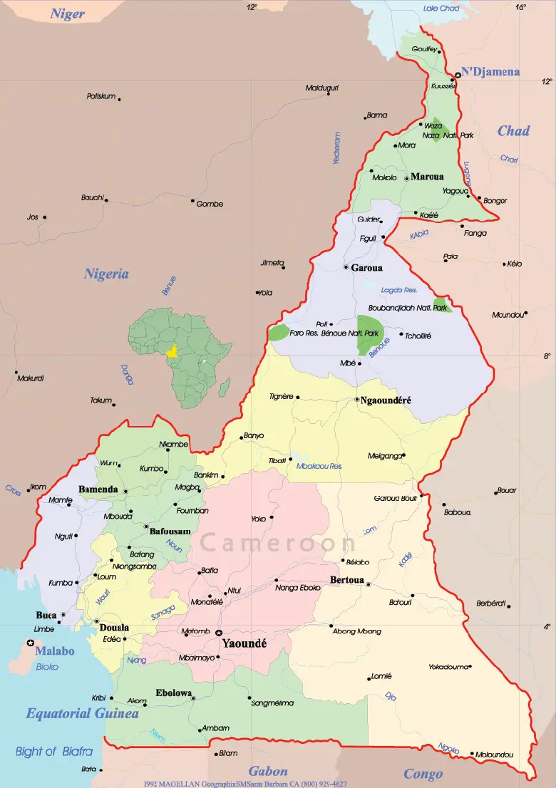
The constitution divides Cameroon into 10 semi-autonomous
regions, each under the administration of an elected Regional Council. Each
region is headed by a presidentially appointed governor.[26]
These leaders are charged with implementing the will of the
president, reporting on the general mood and conditions of the regions,
administering the civil service, keeping the peace, and overseeing the heads of
the smaller administrative units. Governors have broad powers: they may order
propaganda in their area and call in the army, gendarmes, and police.[26] All
local government officials are employees of the central government's Ministry
of Territorial Administration, from which local governments also get most of
their budgets.[7]
Atlas: Cameroon
The regions are subdivided into 58 divisions (French départements). These are headed by presidentially appointed divisional officers (préfets). The divisions are further split into sub-divisions (arrondissements), headed by assistant divisional officers (sous-prefets). The districts, administered by district heads (chefs de district), are the smallest administrative units.[45]
The three northernmost regions are the Far North (Extrême Nord), North (Nord), and Adamawa (Adamaoua). Directly south of them are the Centre (Centre) and East (Est). The South Province (Sud) lies on the Gulf of Guinea and the southern border. Cameroon's western region is split into four smaller regions: the Littoral (Littoral) and Southwest (Sud-Ouest) regions are on the coast, and the Northwest (Nord-Ouest) and West (Ouest) regions are in the western grassfields.[45]
Cameroon Maps | Maps of Cameroon

In 2010, the literacy rate of Cameroon was estimated to be
71.3% (male 78.3% and female 64.8%).[1] Most children have access to state-run
schools that are cheaper than private and religious facilities.[46] The
educational system is a mixture of British and French precedents[47] with most
instruction in English or French.[48]
Cameroon has one of the highest school attendance rates in
Africa.[46] Girls attend school less regularly than boys do because of cultural
attitudes, domestic duties, early marriage, pregnancy, and sexual harassment.
Although attendance rates are higher in the south,[46] a disproportionate
number of teachers are stationed there, leaving northern schools chronically
understaffed.[37]
School attendance in Cameroon is also affected by child
labor. Indeed, the U.S. Department of Labor Findings on the Worst Forms of
Child Labor reported that 56% of children aged 5 to 14 were working children
and that almost 53% of children aged 7 to 14 combined work and school.[49] In
December 2014, a List of Goods Produced by Child Labor or Forced Labor issued
by the Bureau of International Labor Affairs mentioned Cameroon among the
countries that resorted to child labor in the production of cocoa.[50]
Map of Cameroon - Travel Africa

The quality of health care is generally low.[51] In Cameroon, there is only one doctor for every 5,000 people, according to the World Health Organization.[52] Due to financial cuts in the health care system there are few professionals. Doctors and nurses who were trained in Cameroon, emigrate because in Cameroon the payment is bad for too much work. Nurses are unemployed even though their help is needed. Some of them even help out voluntarily so they will not lose their skills.[53] Outside the major cities, facilities are often dirty and poorly equipped.[54]
Cameroon Map, Cameroon Travel Maps from Word Travels
Life expectancy at birth is estimated to be 54.71 years in 2012, among the lowest in the world.[55] Endemic diseases include dengue fever, filariasis, leishmaniasis, malaria, meningitis, schistosomiasis, and sleeping sickness.[56] The HIV/AIDS seroprevalence rate is estimated at 5.4% for those aged 15–49,[57] although a strong stigma against the illness keeps the number of reported cases artificially low.[51] Breast ironing, a traditional practice that is prevalent in Cameroon, may affect girls' health.[58][59][60][61] Female genital mutilation (FGM), while not widespread, is practiced among some populations; according to a 2013 UNICEF report,[62] 1% of women in Cameroon have undergone FGM. Traditional healers remain a popular alternative to Western medicine.[63]
Cameroon Map / Geography of Cameroon
The Cameroon Armed Forces, (French: Forces Armees Camerounaises, FAC) as of 2013, consists of the country's army (French: L'Armee de Terre), the country's navy (French: Marine Nationale Republique (MNR), includes naval infantry), the Cameroonian Air Force (French: Armee de l'Air du Cameroun, AAC), Fire Fighter Corps, and theGendarmerie (2013).[103]
Males and females that are 18 years of age up to 23 years of age and have graduated high school are eligible for military service. Those that do so are obliged 4 years of service. There is no conscription in Cameroon, but the government makes periodic calls for volunteers. [104]
Cameroon Maps - Perry ...
 T
T
he European languages introduced during colonialism have
created a linguistic divide between the population who live in the Northwest
and Southwest regions and the French-speaking remainder of the country.[124]
Both English and French are official languages, although French is by far the
most understood language (80+%).[125]
map_of_cameroon

German, the language of the original colonisers, has long since been displaced by French and English. Cameroonian Pidgin English is the lingua franca in the formerly British-administered territories.[126] A mixture of English, French, and Pidgin called FrancAnglais has been gaining popularity in urban centres since the mid-1970s.[127][128]
cameroon-map.jpg

Cameroon has a high level of religious freedom and
diversity.[37] The predominant faith is Christianity, practiced by about
two-thirds of the population, while Islam is a significant minority faith,
adhered to by about one-fifth. In addition, traditional faiths are practiced by
many. Muslims are most concentrated in the north, while Christians are
concentrated primarily in the southern and western regions, but practitioners
of both faiths can be found throughout the country.[130] Large cities have
significant populations of both groups.[130] Muslims in Cameroon are divided
into Sunnis, Shias, Ahmadis, Sufis, Muwahhid Muslims and non-denominational
Muslims.[131]
People from the North-West and South-West provinces are
largely Protestant, and the French-speaking regions of the southern and western
regions are largely Catholic.[130] Southern ethnic groups predominantly follow
Christian or traditional African animist beliefs, or a syncretic combination of
the two. People widely believe in witchcraft, and the government outlaws such
practices.[132] Suspected witches are often subject to mob violence.[37] The
Islamist jihadist group Boko Haram has been reported as operating in North
Cameroon.[133]
Cameroon Map / Geography of Cameroon / Map of Cameroon
In the northern regions, the locally dominant Fulani ethnic group is mostly Muslim, but the overall population is fairly evenly divided among Muslims, Christians, and followers of indigenous religious beliefs (called Kirdi ("pagan") by the Fulani).[130] The Bamum ethnic group of the West Region is largely Muslim.[130] Native traditional religions are practiced in rural areas throughout the country but rarely are practiced publicly in cities, in part because many indigenous religious groups are intrinsically local in character.[130]
cameroon-map-physical

Traditional arts and crafts are practiced throughout the
country for commercial, decorative, and religious purposes. Woodcarvings and
sculptures are especially common.[151] The high-quality clay of the western
highlands is suitable for pottery and ceramics.[135] Other crafts include
basket weaving, beadworking, brass and bronze working, calabash carving and
painting, embroidery, and leather working. Traditional housing styles make use
of locally available materials and vary from temporary wood-and-leaf shelters
of nomadic Mbororo to the rectangular mud-and-thatch homes of southern peoples.
Dwellings made from materials such as cement and tin are increasingly
common.[152] Contemporary art is mainly promoted by independent cultural
organizations (Doual'art, Africréa) and artist-run initiatives (Art Wash,
Atelier Viking, ArtBakery).[153]
General physical map of Cameroon

Hiç yorum yok:
Yorum Gönder