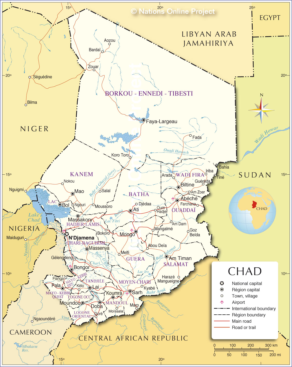
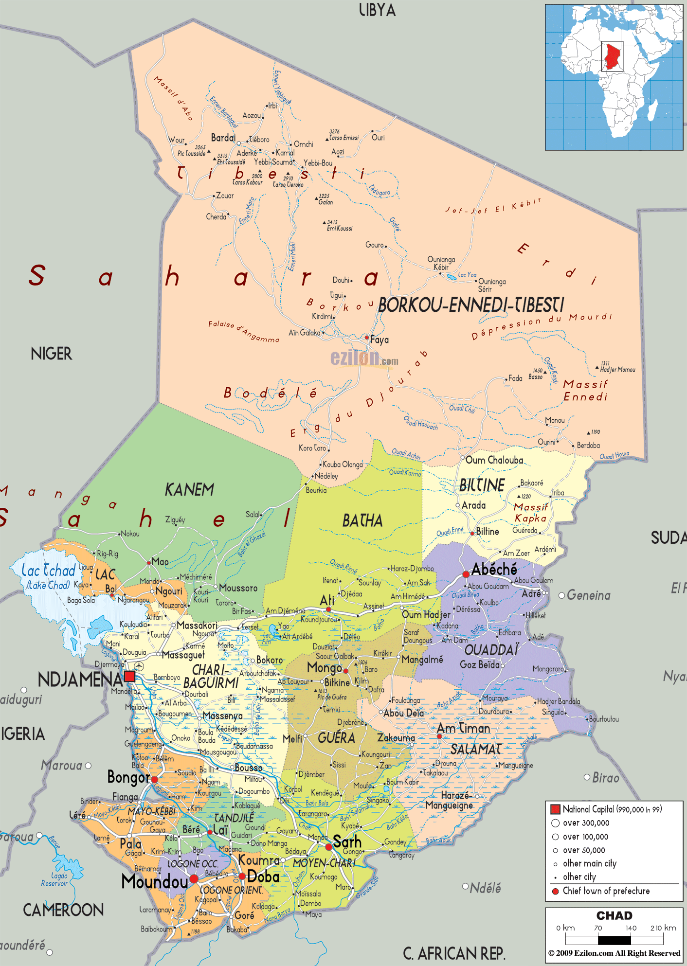
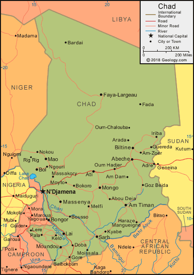
Political Map of Chad
Chad (Listeni/tʃæd/; Arabic: تشاد
Tshād; French: Tchad), officially the Republic of Chad (Arabic: جمهورية تشاد Jumhūrīyat Tshād; French: République du
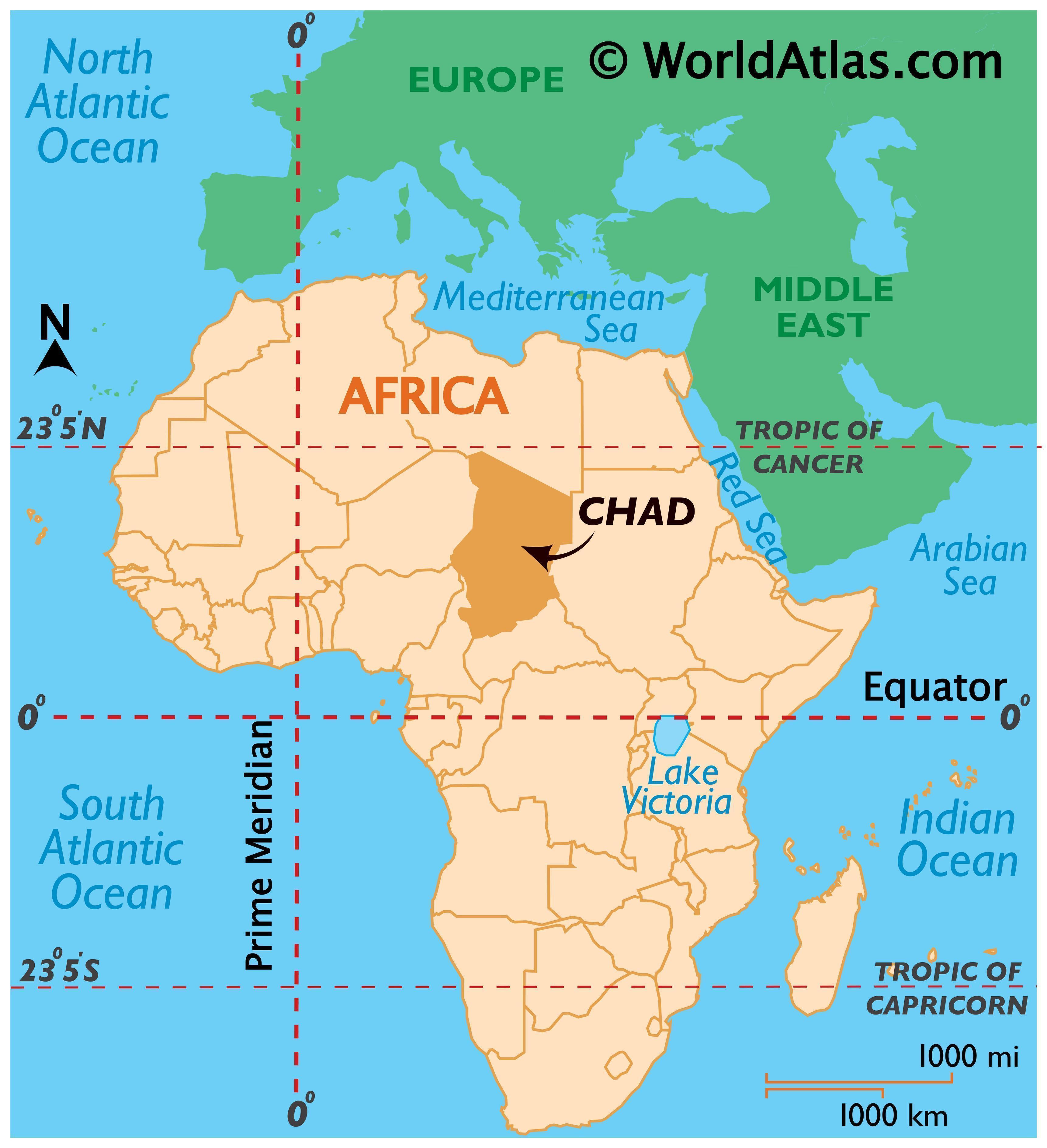
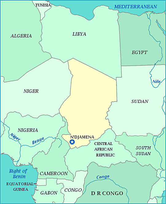
Tchad), is a landlocked country in Central Africa. It is bordered by Libya to
the north, Sudan to the east, the Central African Republic to the south,
Cameroon and Nigeria to the southwest and Niger to the west. It is the fifth
largest country in Africa in terms of area.
While many political parties are active, power lies firmly
in the hands of President Déby and his political party, the Patriotic Salvation
Movement. Chad remains plagued by political violence and recurrent attempted
coups d'état. Chad is one of the poorest and most corrupt countries in the
world; most inhabitants live in poverty as subsistence herders and farmers.
Since 2003, crude oil has become the country's primary source of export
earnings, superseding the traditional cotton industry.
Political Map of Chad

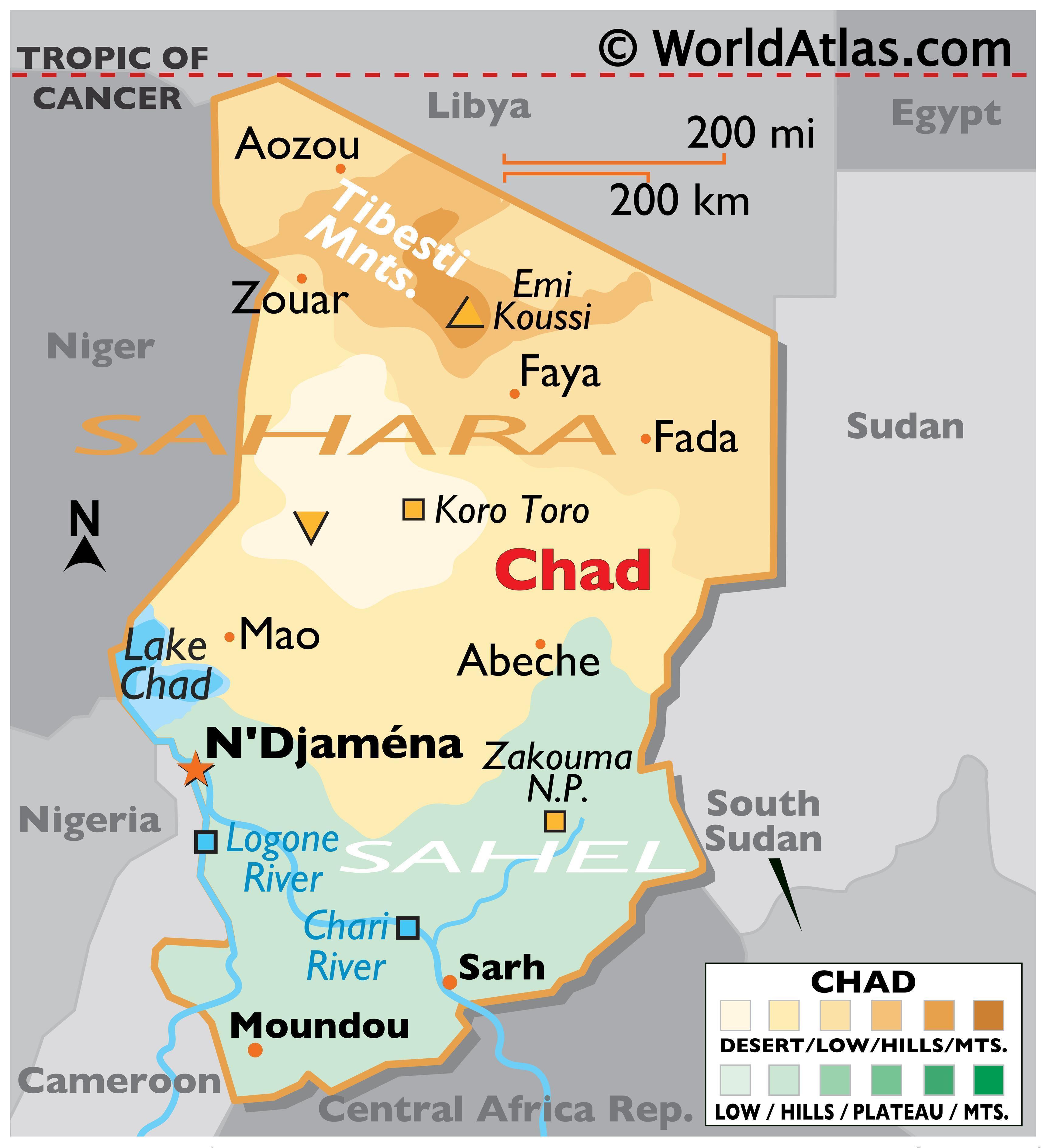
Chad has several regions: a desert zone in the north, an arid Sahelian belt in the centre and a more fertile Sudanian Savanna zone in the south. Lake Chad, after which the country is named, is the largest wetland in Chad and the second-largest in Africa. N'Djamena, the capital, is the largest city. Chad is home to over 200 different ethnic and linguistic groups. Arabic and French are the official languages. Islam and Christianity are the most widely practiced religions.
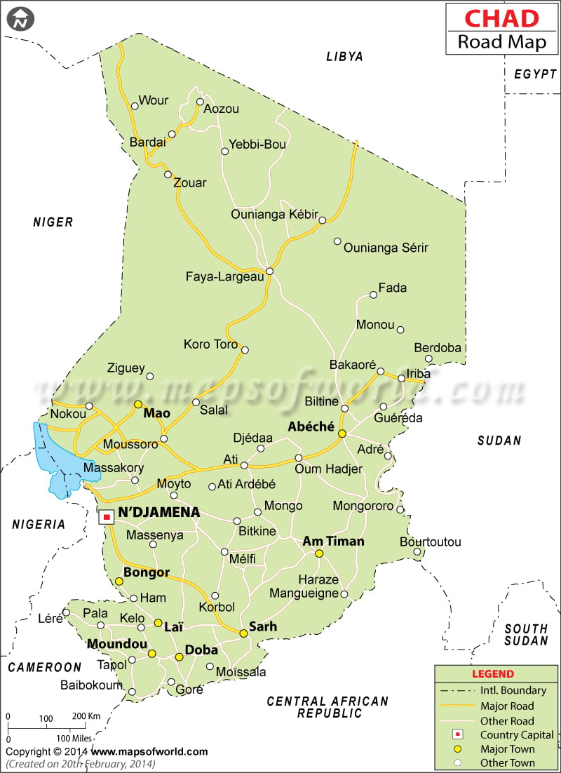
Road Map of Chad

Beginning in the 7th millennium BC, human populations moved into the Chadian basin in great numbers. By the end of the 1st millennium BC, a series of states and empires rose and fell in Chad's Sahelian strip, each focused on controlling the trans-Saharan trade routes that passed through the region. France conquered the territory by 1920 and incorporated it as part of French Equatorial Africa. In 1960, Chad obtained independence under the leadership of François Tombalbaye. Resentment towards his policies in the Muslim north culminated in the eruption of a long-lasting civil war in 1965. In 1979, the rebels conquered the capital and put an end to the south's hegemony. However, the rebel commanders fought amongst themselves until Hissène Habré defeated his rivals. He was overthrown in 1990 by his general Idriss Déby. Since 2003, the Darfur crisis in Sudan has spilt over the border and destabilised the nation, with hundreds of thousands of Sudanese refugees living in and around camps in eastern Chad.
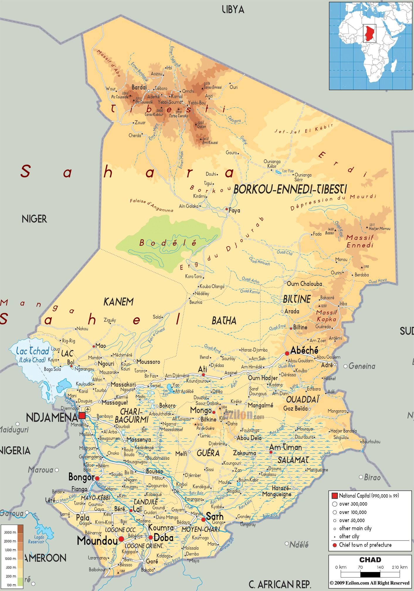
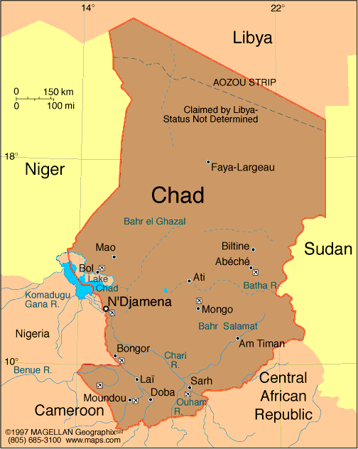
Physical Map of Chad
At 1,284,000 square kilometres (496,000 sq mi),[1] Chad is
the world's 21st-largest country. It is slightly smaller than Peru and slightly
larger than South Africa.[33][34] Chad is in north central Africa, lying
between latitudes 7° and 24°N, and 13° and 24°E.[35]
Political Map of Chad
Chad is bounded to the north by Libya, to the east by Sudan, to the west by Niger, Nigeria and Cameroon, and to the south by the Central African Republic. The country's capital is 1,060 kilometres (660 mi) from the nearest seaport, Douala, Cameroon.[35][36] Because of this distance from the sea and the country's largely desert climate, Chad is sometimes referred to as the "Dead Heart of Africa".[37]
Chad Physical Map | Physical Map of Chad

The dominant physical structure is a wide basin bounded to the north and east by the Ennedi Plateau and Tibesti Mountains, which include Emi Koussi, a dormant volcano that reaches 3,414 metres (11,201 ft) above sea level. Lake Chad, after which the country is named, is the remains of an immense lake that occupied 330,000 square kilometres (130,000 sq mi) of the Chad Basin 7,000 years ago.[35] Although in the 21st century it covers only 17,806 square kilometres (6,875 sq mi), and its surface area is subject to heavy seasonal fluctuations,[38] the lake is Africa's second largest wetland.[39]
Map of Chad - Travel Africa

The region's tall grasses and extensive marshes make it favourable for birds, reptiles, and large mammals. Chad's major rivers—the Chari, Logone and their tributaries—flow through the southern savannas from the southeast into Lake Chad.[35][40]
Chad Map / Geography of Chad
The region's tall grasses and extensive marshes make it favourable for birds, reptiles, and large mammals. Chad's major rivers—the Chari, Logone and their tributaries—flow through the southern savannas from the southeast into Lake Chad.[35][40]
chad-road-map
Each year a tropical weather system known as the
intertropical front crosses Chad from south to north, bringing a wet season
that lasts from May to October in the south, and from June to September in the
Sahel.[41] Variations in local rainfall create three major geographical zones.
The Sahara lies in the country's northern third. Yearly precipitations
throughout this belt are under 50 millimetres (2.0 in); only the occasional
spontaneous palm grove survives, and the only ones to do so are south of the
Tropic of Cancer.[36]
The Sahara gives way to a Sahelian belt in Chad's centre;
precipitation there varies from 300 to 600 mm (11.8 to 23.6 in) per year. In
the Sahel, a steppe of thorny bushes (mostly acacias) gradually gives way to
the south to East Sudanian savanna in Chad's Sudanese zone. Yearly rainfall in
this belt is over 900 mm (35.4 in).[36]
Chad Map - Chad Satellite Image - Physical - Political
As of 2011, Chad currently spends 1.6% of GDP
on its army, a drastic drop from the level of 2009 (4.2% of GDP), when the
country was engaged in a civil
war, with rebels
supported by neighboring Sudan.[83] This then
increased to 2.0% of GDP in 2013, when Chad began its military
intervention in Northern Mali, to help France and other
African nations in bringing back Mali's sovereignty over the North. The army
has over 30,350 active personnel and 3,000,000 fit for military service, making
it the most efficient force in the region besides the army of Sudan.
Map of Chad
Chad Political Map

There have been numerous rebel groups in Chad throughout the last few decades. In 2007, a peace treaty was signed that integrated United Front for Democratic Change orFUC soldiers into the Chadian Army.[84] The Movement for Justice and Democracy in Chad or MDJT also clashed with government forces in 2003 in an attempt to overthrow President Idriss Déby. In addition, there have been various conflicts with Khartoum's Janjaweed rebels in Eastern Chad who killed civilians by use of helicopter gunships.[85]Presently, the Union of Resistance Forces or UFR are a rebel group that continues to battle with the government of Chad. In 2010, the UFR reportedly had a force estimating 6,000 men and 300 vehicles.[86]
The United Nations' Human Development Index ranks Chad as the seventh poorest country in the world, with 80% of the population living below the poverty line. The GDP (Purchasing power parity) per capita was estimated as US$1,651 in 2009.[4] Chad is part of the Bank of Central African States, the Customs and Economic Union of Central Africa (UDEAC) and the Organization for the Harmonization of Business Law in Africa (OHADA).[87]
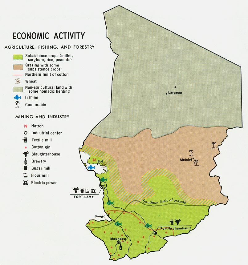
Chad's currency is the CFA franc. In the 1960s, the Mining industry of Chad produced sodium carbonate, or natron. There have also been reports of gold-bearing quartz in the Biltine Prefecture. However, years of civil war have scared away foreign investors; those who left Chad between 1979 and 1982 have only recently begun to regain confidence in the country's future. In 2000 major direct foreign investment in the oil sector began, boosting the country's economic prospects.[33][55]
Geography of Chad - Wikipedia, the free encyclopedia

Women in Mao, where water is provided by a water tower. Access to clean water is often a problem in Chad.
Over 80% of Chad's population relies on subsistence farming and livestock raising for its livelihood.[33] The crops grown and the locations of herds are determined by the local climate. In the southernmost 10% of the territory lies the nation's most fertile cropland, with rich yields of sorghum and millet. In the Sahel only the hardier varieties of millet grow, and these with much lower yields than in the south. On the other hand, the Sahel is ideal pastureland for large herds of commercial cattle and for goats, sheep, donkeys and horses. The Sahara's scattered oases support only some dates and legumes.[7] Chad's cities face serious difficulties of municipal infrastructure; only 48% of urban residents have access to potable water and only 2% to basic sanitation.[35][76]
Chad Maps | Maps of Chad

Before the development of oil industry, cotton dominated industry and the labour market had accounted for approximately 80% of export earnings.[88] Cotton remains a primary export, although exact figures are not available. Rehabilitation of Cotontchad, a major cotton company weakened by a decline in world cotton prices, has been financed by France, the Netherlands, the European Union, and the International Bank for Reconstruction and Development (IBRD). The parastatal is now expected to be privatised.[55]
If Chad can maintain a semblance of stability foreign investments will eventually return, but even 24 years after the last successful coup that brought President Idris Deby to power, investors are still wary of investing in Chad.[89]
Atlas: Chad
Chad's energy sector has had years of
mismanagement by the parastatal Chad Water and Electric Society (STEE), which
provides power for 15% of the capital's citizens and covers only 1.5% of the
national population.[97] Most Chadians burn biomass fuels such as wood and
animal manure for power.[98]
Chad Political Map | Political Map of Chad | Political Chad ...

ExxonMobil leads a consortium of Chevron and Petronas that has invested $3.7 billion to develop oil reserves estimated at one billion barrels in southern Chad. Oil production began in 2003 with the completion of a pipeline (financed in part by the World Bank) that links the southern oilfields to terminals on the Atlantic coast of Cameroon. As a condition of its assistance, the World Bank insisted that 80% of oil revenues be spent on development projects. In January 2006 the World Bank suspended its loan programme when the Chadian government passed laws reducing this amount.[55][79] On 14 July 2006, the World Bank and Chad signed a memorandum of understanding under which the Government of Chad commits 70% of its spending to priority poverty reduction programmes.[99]
Cities in Chad | Chad Cities Map

Football is Chad's most popular sport.[122] The
country's national team is closely followed during international
competitions[112] and Chadian footballers have played for French teams.
Basketball and freestyle wrestling are widely practiced, the latter in a form
in which the wrestlers put on traditional animal hides and cover themselves
with dust.[112]
Chad Maps - Perry
Millet is the staple food throughout Chad. It
is used to make balls of paste that are dipped in sauces. In the north this
dish is known asalysh; in the south, as biya. Fish is popular, which is
generally prepared and sold either as salanga (sun-dried and lightly
smokedAlestes and Hydrocynus) or as banda (smoked large fish).[114] Carcaje is
a popular sweet red tea extracted from hibiscus leaves. Alcoholic beverages,
though absent in the north, are popular in the south, where people drink millet
beer, known as billi-billi when brewed from red millet, and as coshate when
from white millet.[112]
Chad travel guide - Wikitravel

Millet is the staple food throughout Chad. It
is used to make balls of paste that are dipped in sauces. In the north this
dish is known asalysh; in the south, as biya. Fish is popular, which is
generally prepared and sold either as salanga (sun-dried and lightly
smokedAlestes and Hydrocynus) or as banda (smoked large fish).[114] Carcaje is
a popular sweet red tea extracted from hibiscus leaves. Alcoholic beverages,
though absent in the north, are popular in the south, where people drink millet
beer, known as billi-billi when brewed from red millet, and as coshate when
from white millet.[112]
Chad Map / Geography of Chad / Map of Chad -
Hiç yorum yok:
Yorum Gönder