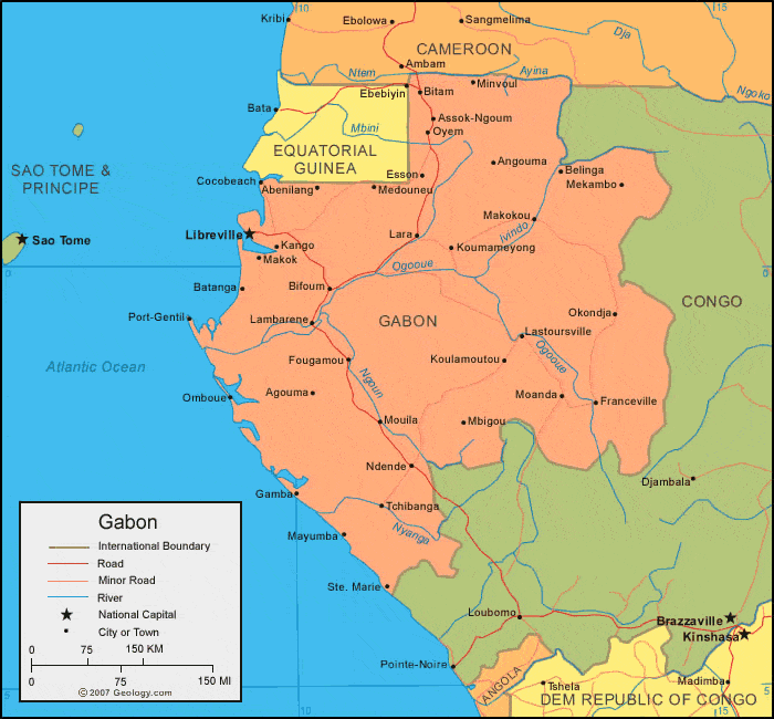
Gabon Map - Gabon Satellite Image - Physical - Political
Gabon (/ɡəˈbɒn/; French pronunciation:
[ɡabɔ̃]), officially the Gabonese Republic (French: République gabonaise), is
a sovereign state on the west coast of Central Africa. Located on the equator,
Gabon is bordered by Equatorial Guinea to the northwest, Cameroon to the north,
the Republic of the Congo on the east and south, and the Gulf of Guinea to the
west. It has an area of nearly 270,000 square kilometres (100,000 sq mi) and
its population is estimated at 1.5 million people. Its capital and largest city
is Libreville.
Free Political Map of Gabon, satellite outside

Since its independence from France in 1960, Gabon has had three presidents. In the early 1990s, Gabon introduced a multi-party system and a new democratic constitution that allowed for a more transparent electoral process and reformed many governmental institutions. Gabon was also a non-permanent member of the United Nations Security Council for the 2010–2011 term.
satellite-3d-map-of-gabon.jpg

Low population density, abundant petroleum, and foreign private investment have helped make Gabon one of the most prosperous countries in Sub-Saharan Africa, with the 4th highest HDI[3] and the third highest GDP per capita (PPP) (after Equatorial Guinea and Botswana) in the region.
Gabon Map - Gabon Satellite Image - Physical - Political
The earliest inhabitants of the area were Pygmy
peoples. They were largely replaced and absorbed by Bantu tribes as they
migrated.
In the 15th century, the first Europeans
arrived. By the 18th century, a Myeni speaking kingdom known as Orungu formed
in Gabon.
On February 10, 1722, Bartholomew Roberts, a
Welsh pirate known as Black Bart, died at sea off Cape Lopez. He raided ships
off the Americas and West Africa from 1719 to 1722.
French explorer Pierre Savorgnan de Brazza led
his first mission to the Gabon-Congo area in 1875. He founded the town of
Franceville, and was later colonial governor. Several Bantu groups lived in the
area that is now Gabon when France officially occupied it in 1885.
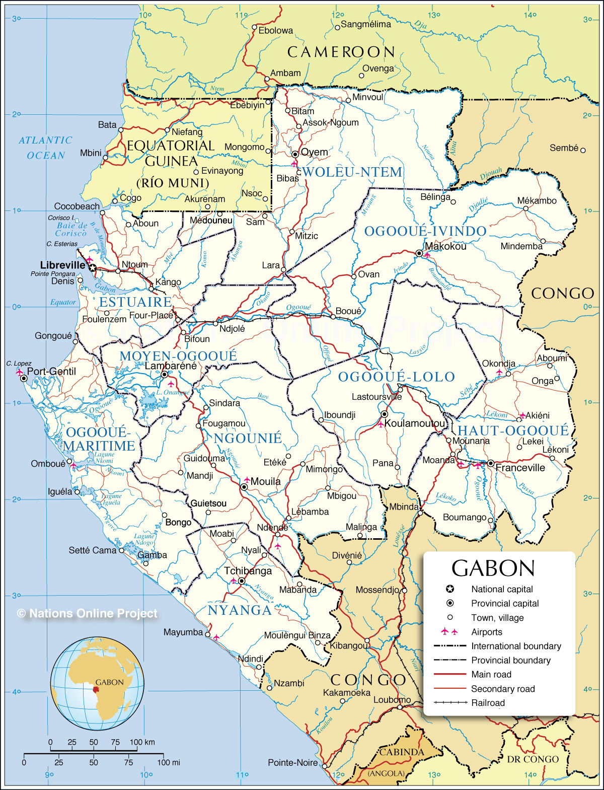
Administrative Map of Gabon
Free Flag Map of Gabon, satellite outside, flag centered

In 1910 Gabon became one of the four territories of French Equatorial Africa, a federation that survived until 1959. These territories became independent on August 17, 1960. The first president of Gabon, elected in 1961, was Léon M'ba, with Omar Bongo Ondimba as his vice president.
After M'ba's accession to power, the press was suppressed, political demonstrations banned, freedom of expression curtailed, other political parties gradually excluded from power, and the Constitution changed along French lines to vest power in the Presidency, a post that M'ba assumed himself. However, when M'ba dissolved the National Assembly in January 1964 to institute one-party rule, an army coup sought to oust him from power and restore parliamentary democracy. French paratroopers flew in within 24 hours to restore M'ba to power.
Free Flag 3D Map of Gabon, satellite outside, flag rotated

Atlas of Gabon - Wikimedia Commons

After a few days of fighting, the coup ended and the opposition was imprisoned, despite widespread protests and riots. French soldiers still remain in the Camp de Gaulle on the outskirts of Gabon's capital to this day. When M'Ba died in 1967, Bongo replaced him as president.
In March 1968, Bongo declared Gabon a one-party state by dissolving the BDG and establishing a new party — the Parti Democratique Gabonais (PDG). He invited all Gabonese, regardless of previous political affiliation, to participate. Bongo sought to forge a single national movement in support of the government's development policies, using the PDG as a tool to submerge the regional and tribal rivalries that had divided Gabonese politics in the past. Bongo was elected President in February 1975; in April 1975, the position of vice president was abolished and replaced by the position of prime minister, who had no right to automatic succession. Bongo was re-elected President in both December 1979 and November 1986 to 7-year terms.[4]
In early 1990 economic discontent and a desire for political liberalization provoked violent demonstrations and strikes by students and workers. In response to grievances by workers, Bongo negotiated with them on a sector-by-sector basis, making significant wage concessions. In addition, he promised to open up the PDG and to organize a national political conference in March–April 1990 to discuss Gabon's future political system. The PDG and 74 political organizations attended the conference. Participants essentially divided into two loose coalitions, the ruling PDG and its allies, and the United Front of Opposition Associations and Parties, consisting of the breakaway Morena Fundamental and the Gabonese Progress Party.[4]
The April 1990 conference approved sweeping political reforms, including creation of a national Senate, decentralization of the budgetary process, freedom of assembly and press, and cancellation of an exit visa requirement. In an attempt to guide the political system's transformation to multiparty democracy, Bongo resigned as PDG chairman and created a transitional government headed by a new Prime Minister, Casimir Oye-Mba. The Gabonese Social Democratic Grouping (RSDG), as the resulting government was called, was smaller than the previous government and included representatives from several opposition parties in its cabinet. The RSDG drafted a provisional constitution in May 1990 that provided a basic bill of rights and an independent judiciary but retained strong executive powers for the president. After further review by a constitutional committee and the National Assembly, this document came into force in March 1991.[4]
Opposition to the PDG continued after the April 1990 conference, however, and in September 1990, two coup d'état attempts were uncovered and aborted. Despite anti-government demonstrations after the untimely death of an opposition leader, the first multiparty National Assembly elections in almost 30 years took place in September–October 1990, with the PDG garnering a large majority.[4]
Following President Omar Bongo's re-election in December 1993 with 51% of the vote, opposition candidates refused to validate the election results. Serious civil disturbances led to an agreement between the government and opposition factions to work toward a political settlement. These talks led to the Paris Accords in November 1994, under which several opposition figures were included in a government of national unity. This arrangement soon broke down, however, and the 1996 and 1997 legislative and municipal elections provided the background for renewed partisan politics. The PDG won a landslide victory in the legislative election, but several major cities, including Libreville, elected opposition mayors during the 1997 local election.[4]
satellite-map-of-gabon.jpg

Facing a divided opposition, President Omar Bongo coasted to easy re-election in December 1998, with large majorities of the vote. While Bongo's major opponents rejected the outcome as fraudulent, some international observers characterized the results as representative despite many perceived irregularities, and there were none of the civil disturbances that followed the 1993 election. Peaceful though flawed legislative elections held in 2001–2002, which were boycotted by a number of smaller opposition parties and were widely criticized for their administrative weaknesses, produced a National Assembly almost completely dominated by the PDG and allied independents. In November 2005 President Omar Bongo was elected for his sixth term. He won re-election easily, but opponents claim that the balloting process was marred by irregularities. There were some instances of violence following the announcement of his win, but Gabon generally remained peaceful.[4]
National Assembly elections were held again in December 2006. Several seats contested because of voting irregularities were overturned by the Constitutional Court, but the subsequent run-off elections in early 2007 again yielded a PDG-controlled National Assembly.[4]
Gabon map | Africa map | Satellite City

On June 8, 2009, President Omar Bongo died of cardiac arrest at a Spanish hospital in Barcelona, ushering in a new era in Gabonese politics. In accordance with the amended constitution, Rose Francine Rogombé, the President of the Senate, became Interim President on June 10, 2009. The first contested elections in Gabon's history that did not include Omar Bongo as a candidate were held on August 30, 2009 with 18 candidates for president. The lead-up to the elections saw some isolated protests, but no significant disturbances. Omar Bongo's son, ruling party leader Ali Bongo Ondimba, was formally declared the winner after a 3-week review by the Constitutional Court; his inauguration took place on October 16, 2009.[4]

The court's review had been prompted by claims of fraud by the many opposition candidates, with the initial announcement of election results sparking unprecedented violent protests in Port-Gentil, the country's second-largest city and a long-time bastion of opposition to PDG rule. The citizens of Port-Gentil took to the streets, and numerous shops and residences were burned, including the French Consulate and a local prison. Officially, only four deaths occurred during the riots, but opposition and local leaders claim many more. Gendarmes and the military were deployed to Port-Gentil to support the beleaguered police, and a curfew was in effect for more than 3 months.[4]
Gabon Shaded Relief Map - Gabon
A partial legislative by-election was held in June 2010. A newly created coalition of parties, the Union Nationale (UN), participated for the first time. The UN is composed largely of PDG defectors who left the party after Omar Bongo's death. Of the five hotly contested seats, the PDG won three and the UN won two; both sides claimed victory.[
Geography of Gabon
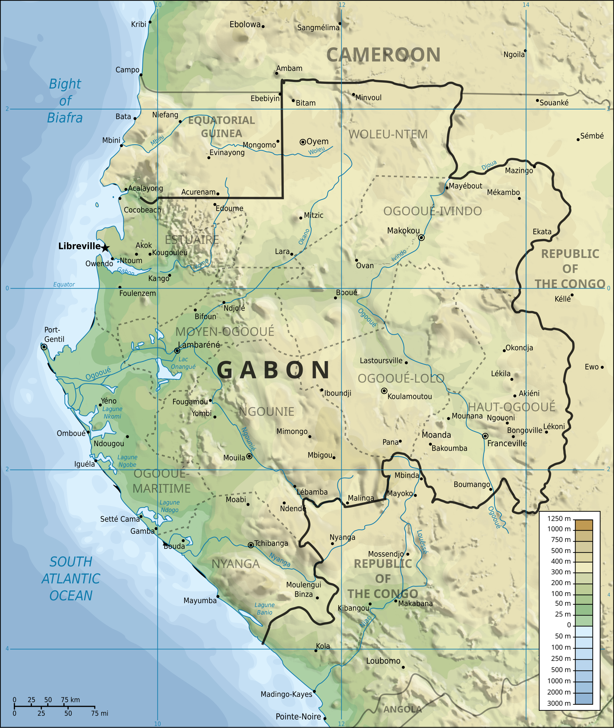
Gabon is located on the Atlantic coast of
central Africa. Located on the equator, between latitudes 3°N and 4°S, and
longitudes 8° and 15°E. Gabon generally has an equatorial climate with an
extensive system of rainforests covering 85% of the country.
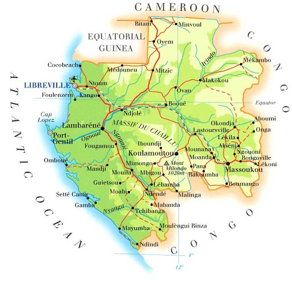
There are three distinct regions: the coastal
plains (ranging between 20 to 300 km from the ocean's shore), the mountains
(the Cristal Mountains to the northeast of Libreville, the Chaillu Massif in
the centre), and the savanna in the east. The coastal plains form a large
section of the World Wildlife Fund's Atlantic Equatorial coastal forests
ecoregion and contain patches of Central African mangroves especially on the
Muni River estuary on the border with Equatorial Guinea.
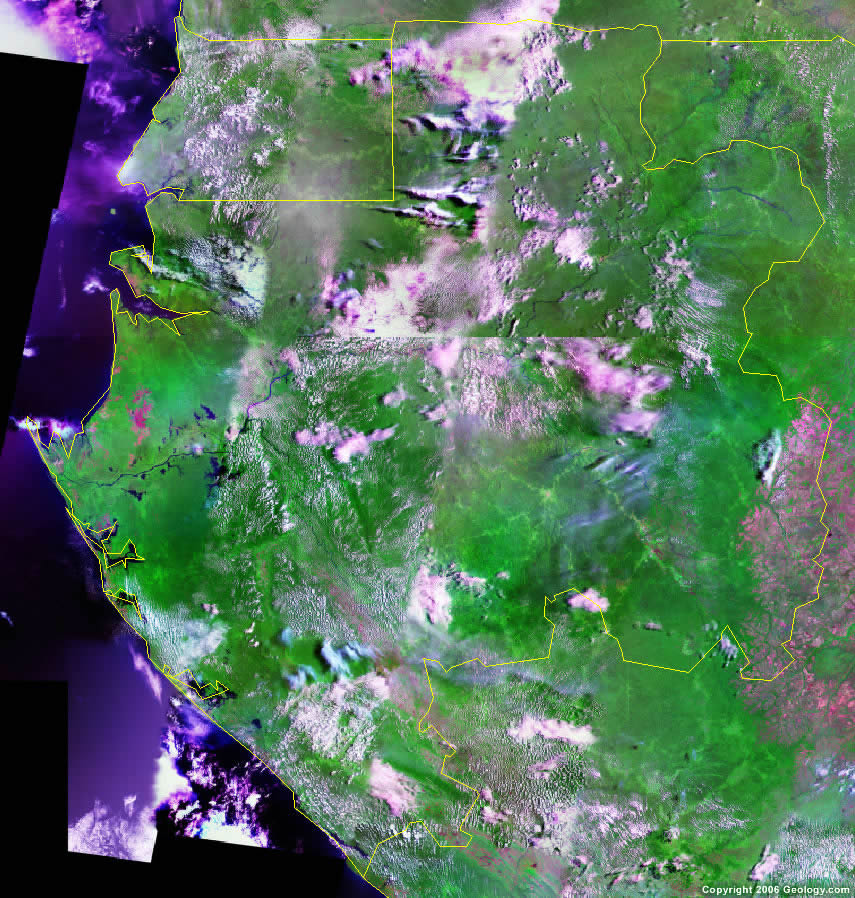
Satellite Photo | Satellite Images | Gabon

Gabon's largest river is the Ogooué which is 1200 km long. Gabon has three karst areas where there are hundreds of caves located in the dolomite and limestone rocks. Some of the caves include Grotte du Lastoursville, Grotte du Lebamba, Grotte du Bongolo, and Grotte du Kessipougou. Many caves have not been explored yet. A National Geographic Expedition visited the caves in the summer of 2008 to document them (Expedition Website).
Gabon Africa True Colour Satellite Image With Border Stock

Gabon is also noted for efforts to preserve the natural environment. In 2002, President Omar Bongo Ondimba put Gabon firmly on the map as an important future ecotourism destination by designating roughly 10% of the nation's territory to be part of its national park system (with 13 parks in total), one of the largest proportions of nature parkland in the world. The National Agency for National Parks manages Gabon's national park system.
Natural resources include: petroleum, magnesium, iron, gold, uranium, and forests.
satellite-map-of-gabon-

Almost all Gabonese are of Bantu origin. Gabon has at least forty ethnic groups with differing languages and cultures.[4] The Fang are generally thought to be the largest,[4] although recent census data seem to favor the Nzebi.[citation needed] Others include the Myene, Kota, Shira, Puru, and Kande.[4] Ethnic boundaries are less sharply drawn in Gabon than elsewhere in Africa. There are also various Pygmy peoples: the Bongo, Kota, and Baka; the latter speak the only non-Bantu language in Gabon.
Satellite Location Map of Gabon

Most ethnicities are spread throughout Gabon, leading to constant contact and interaction among the groups. Intermarriage between the ethnicities is quite common, helping reduce ethnic tensions. French, the language of its former colonial ruler, is a unifying force. The Democratic Party of Gabon (PDG)'s historical dominance also has served to unite various ethnicities and local interests into a larger whole. More than 10,000 native French live in Gabon, including an estimated 2,000 dual nationals.[4]
Population centres[edit]
Hiç yorum yok:
Yorum Gönder